Pick the Method That Proves Itself

The right reality-capture choice for BIM isn’t LiDAR or photogrammetry — it’s whichever can prove it meets your tolerance and information requirements. Start from USIBD LOA v3.1 and frame accuracy in standard-deviation terms so acceptance isn’t subjective. Use ISO 19650 to anchor deliverables, naming, and metadata, then demand a transparent check like ASTM E3125 to verify results — not just specs. Tripod TLS delivers repeatable millimeter-class geometry in tough interiors; SLAM LiDAR trades a bit of absolute accuracy for speed and scales well when you plan loop closures and checkpoints; photogrammetry wins on coverage and visual richness but only reaches BIM-tight tolerances with thoughtful control design and calibration. Most projects land on a hybrid: UAV imagery for the envelope, TLS for cores and dense MEP, SLAM for rapid coverage with TLS anchors. In narrow, high-throughput corridors, a tailored loop-closure strategy can trim drift; otherwise off-the-shelf pipelines suffice. Define outcomes, specify how proof will be produced, and the “LiDAR vs photogrammetry” debate resolves into a defensible plan.

Common Questions

Q: How do I decide between LiDAR and photogrammetry without bias? A: Start from the required LOA tolerance and ISO 19650 deliverables, then pick the method that can prove compliance via an acceptance test (e.g., ASTM E3125). Tools follow requirements — not the other way around.

Q: When does SLAM LiDAR beat tripod TLS? A: When speed and coverage across large interiors matter more than millimeter-class repeatability. Plan loop closures and surveyed checkpoints; if absolute tolerances tighten later, add a few TLS “anchors.”

Q: Can photogrammetry really hit BIM-tight tolerances? A: Yes — if you treat control as design, not decoration. Use RTK/PPK plus well-distributed GCPs (including height breaks), consistent optics, and orthogonal coverage; otherwise expect scale/height drift.

Q: What’s a pragmatic acceptance workflow I can require in contracts? A: Specify LOA v3.1 (SD-based tolerances), mandate an E3125-style test, and request checkpoint RMSEs with raw QA artifacts. Ask for a short validation route or target set the vendor must re-measure on request.

Q: Where do hybrids actually pay off? A: UAV photogrammetry for the envelope, TLS for cores and dense MEP, SLAM for fast floorplate coverage. This reduces site time while preserving accuracy where it matters most.

Q: We have long, feature-poor corridors — how do we control SLAM drift? A: Design closed loops, place periodic anchors (surveyed targets or TLS stations), and rescan a fixed validation path. In high-throughput cases, a tailored loop-closure/anchor-injection step can further cut drift.

Q: What should procurement include beyond “deliver a point cloud”? A: Name LOA targets, acceptance methods, and required metadata per ISO 19650. Require submission of control layouts, processing settings, checkpoint residuals, and an accuracy summary that’s tied to the model zones you’ll actually use.
Contact Elf.3D to explore how custom mesh processing algorithms might address your unique challenges. We approach every conversation with curiosity about your specific needs rather than generic solutions.

*Interested in discussing your mesh processing challenges? We'd be happy to explore possibilities together.*

Choosing Reality Capture for BIM: LiDAR vs Photogrammetry — without the Guesswork

The most defensible way to choose a capture method for BIM is to begin with requirements, not tools. Two anchors help: the USIBD Level of Accuracy (LOA) specification — v3.1 released in 2025 — and the ISO 19650 suite for information management. LOA v3.1 clarifies how to express tolerances using standard deviation (SD) language, making it easier to write acceptance criteria that vendors can test and verify. Coupled with ISO 19650 information-delivery processes, this lets teams specify exactly how accurate “as-built” models must be and how that accuracy will be demonstrated.

Meanwhile, acceptance testing shouldn’t be a guessing game. ASTM E3125-17 defines point-to-point distance tests for medium-range 3D imaging systems (e.g., terrestrial laser scanners and many SLAM devices). Owners can require that suppliers run an E3125-style test and report the results alongside LOA claims; the method is designed to produce comparable, repeatable error numbers. NIST’s documentation explains the test artifacts (including relative-range checks) and their purpose.

What “accuracy” means (and how to prove it)

In practice, reported accuracy is often summarized as an RMSE across checkpoints:

RMSExyz = √ ((1/ n) · Σ (dx2 + dy2 + dz2))

LOA v3.1’s SD-based phrasing helps connect those checkpoint statistics to model tolerances in clear, contractual language. Requesting E3125 reports (or equivalent) with the how and the numbers keeps promises like “±10 mm” honest.

Method profiles: strengths, limits, and realistic expectations

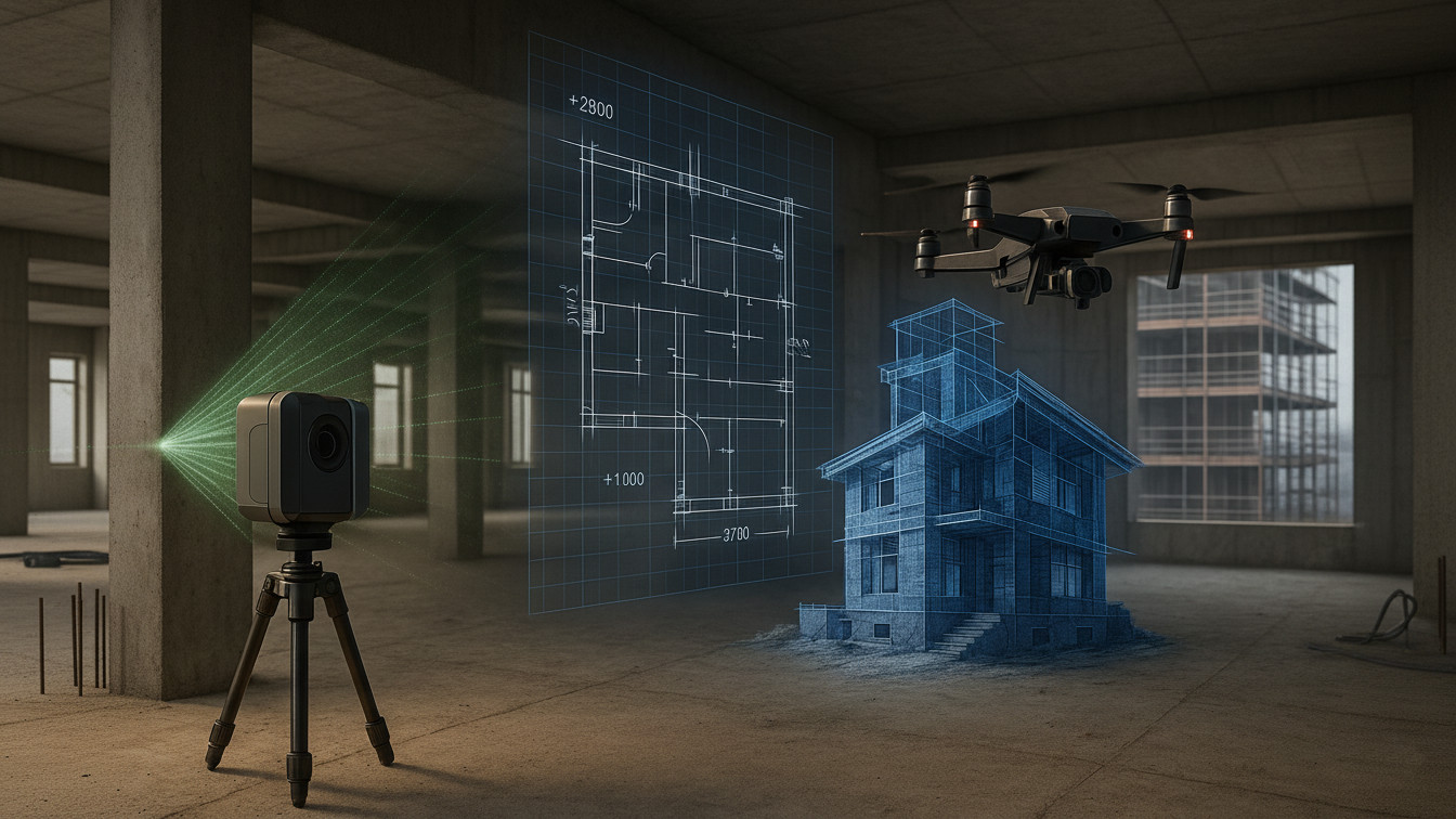
Tripod TLS (static LiDAR). The workhorse for tight tolerances. At short to medium range, modern scanners routinely deliver repeatable millimeter-class results, and they are robust in low-light, low-texture interiors where image matching struggles. TLS also aligns neatly with E3125 acceptance testing, because the test was written around spherical-coordinate systems typical of TLS. The trade-off is slower setup and more stations to plan.

Mobile/SLAM LiDAR. The speed champion indoors. SLAM scanners cover large floorplates quickly; with well-designed loop closures and QA checkpoints, published indoor evaluations report errors on the order of a few millimeters to ~1–1.5 cm, while reputable vendor claims cluster around ±10–15 mm for indoor absolute accuracy. Treat those figures as achievable with good practice, not automatic. Structured spaces help; long, feature-poor corridors increase drift risk unless loops and anchors are planned.

Photogrammetry (UAV/terrestrial). Superb for exteriors and texture-rich scenes, and often the most cost-efficient on a per-area basis. However, photogrammetric metric quality depends strongly on control design and imaging discipline. RTK or PPK image centers reduce fieldwork, but studies keep showing that GCP distribution — especially vertical distribution on roofs or facade features — materially improves height/facade accuracy when tolerances are tight. Classic CIPA 3×3 guidance (coverage, overlap, fixed optics, orthogonal views) remains a practical checklist.

In narrow, high-throughput scenarios, bespoke SLAM loop-closure or anchor-injection routines can reduce drift versus default pipelines; for most building scopes, off-the-shelf workflows are sufficient.

Control and calibration that actually move the needle

For photography, stick to the simple things that work: constant focal settings, adequate overlap, orthogonal passes for rectification, and a thoughtful GCP layout that isn’t confined to a single plane. Where facades and vertical datums matter, add measured points at different heights (e.g., rooflines, parapets); recent work quantifies the improvement when rooftop control is included.

For SLAM, close loops (return to start), place surveyed checkpoints you can re-observe independently, and — where supported — ingest control targets to cap drift and ease geo-registration. Keep a short, repeatable validation route you can rescan if anomalies appear. Published evaluations emphasize that these basics often make the difference between centimeter-class and disappointing results.

Speed, logistics, and cost in the real world

  • TLS: Slower on site but predictable in QC; ideal when mistakes are expensive and lighting/texture are poor. E3125-style tests and LOA reporting fit naturally into TLS-led scopes.
  • SLAM: Fastest for interiors. Plan for validation passes and selective re-scans where drift risk is highest (long, uniform corridors). Published indoor comparisons frame sensible expectations.
  • Photogrammetry: Rapid exterior capture (UAV), compute-heavier downstream; RTK + smart GCPs usually beats “RTK alone” when BIM-tight tolerances are required.

A compact, defensible playbook

  1. State LOA and acceptance tests up front. Cite USIBD LOA v3.1 and require reporting tolerances using SD language; reference ASTM E3125-17 (or equivalent) for point-to-point checks.
  2. Map environment and access. Note lighting, surface texture, reflective/glass areas, occlusions, and safe access for instruments/UAVs.
  3. Choose method + control plan. Decide if the environment favors TLS robustness, SLAM speed, or photogrammetry coverage; design loop closures or GCPs accordingly.
  4. Validate transparently. Share checkpoint RMSEs, E3125 results, and any registration residuals with the model deliverable; keep the chain of custody within ISO 19650’s information-management structure. ISO 19650-6 (published 2025) adds guidance for structured health & safety information that may influence how you plan access and exchange sensitive site data.

Typical ranges & control needs (indicative, project-dependent)

Method Typical indoor accuracy Capture speed Control needs
Tripod TLS ~2–5 mm (short range) Slow–med Targets/registration; E3125 checks
Mobile/SLAM LiDAR ~10–15 mm absolute Fast Closed loops + QA checkpoints
Photogrammetry (UAV/terrestrial) ~5–20 mm with RTK + GCPs Med Strong GCP layout + calibration

Figures reflect standards-based evaluation framing (ASTM E3125), published SLAM accuracy comparisons, and recent RTK/GCP distribution studies — treat them as planning ranges, not guarantees.

Environment sensitivities (rules of thumb)

Condition TLS SLAM LiDAR Photogrammetry
Low light Unaffected Unaffected Degrades (blur/noise)
Low texture/monochrome Strong Strong Degrades (fewer tie points)
Vegetation Penetrates gaps Similar to LiDAR limits Captures canopy “skin”

These patterns align with the fundamental sensing modalities: active range measurement (LiDAR) versus passive image matching (photogrammetry). They explain why, for example, a dark plant room leans TLS, while a textured exterior favors UAV imaging.

Reliable hybrid recipes

  • Envelope + cores. Use UAV photogrammetry (RTK plus well-distributed GCPs, including vertical control where feasible) for the exterior envelope, and TLS for the structural core and dense MEP zones where tolerances tighten. This keeps field time down without compromising critical geometry.
  • SLAM for coverage, TLS for anchors. Sweep large interiors with SLAM to capture coverage quickly, then “lock” the solution with a handful of tripod TLS stations and surveyed targets. Publish the acceptance test and checkpoint report with the deliverable to document absolute accuracy.

Procurement that prevents rework

Small specification changes eliminate big headaches:

  • Reference LOA v3.1 in the SOW and require tolerance reporting using SD language; include an example acceptance table so bidders know exactly what to deliver.
  • Name an acceptance method. Cite ASTM E3125-17 (or a project-specific equivalent) and require vendors to submit raw measurements, processing settings, and results.
  • Tie deliverables to ISO 19650 artifacts. Require metadata, naming, and security practices consistent with the organization’s 19650 implementation; note that Part 6 (2025) brings structured health-and-safety information into scope for both projects and assets.

Bottom line

  • Start from outcomes. LOA v3.1 gives a common way to specify and verify tolerances; ISO 19650 provides the information-management backbone. As of 2025, the LOA update and ISO 19650-6 sharpen both accuracy language and information-sharing expectations.
  • Prove it, don’t hope it. Use E3125-style tests and checkpoint RMSEs to verify the workflow, not just the hardware.
  • Pick the right tool (or mix). TLS wins on consistency in difficult interiors; SLAM wins on speed with well-planned loops and anchors; photogrammetry wins on cost/visual fidelity when control is designed, not assumed. When requirements tighten or environments are hostile to imagery, hybridizing is usually the pragmatic answer.

References (selected)

  1. USIBD LOA v3.1 overview and release notes (2025). (U.S. Institute of Building Documentation)
  2. ASTM E3125-17: point-to-point distance testing for 3D imaging systems; NIST artifact overview. (ASTM International | ASTM)
  3. ISO 19650-6:2025 (health & safety information) and industry summary of its publication. (iso.org)
  4. CIPA 3×3 rules for photogrammetric documentation (capture guidance). (cipaheritagedocumentation.org)
  5. SLAM accuracy comparison (NavVis VLX vs BLK2GO) for indoor/outdoor tasks. (MDPI)
  6. Photogrammetry control design: effect of GCP distribution (including rooftop control) on facade/height accuracy. (DergiPark)